Modern administration and intelligent mobility require highly complete, actual and reliable transport data. The GIP is the basis for such high-quality transport data and enables the exchange between different organisations. It enables a nationwide supply of high-quality transport services in a standardized way as well as an overview for public authorities over the transport infrastructure based on a common data standard.
By implementing the GIP, the Austrian administration has created an integration project which is unique in Europe. Redundancy and parallel tasks concerning the management of transport-related data are now a thing of the past in Austria.


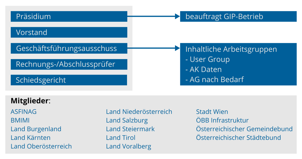
Whereas the GIP started in 2008, nowadays the association „ÖVDAT“ (Austrian Institute for Transport Data Infrastructure) constitutes the administrative structure for the GIP. Since 2016, ITS Vienna Region (a department of the Public Transport Association of the Vienna Region, VOR) has been tasked with operating the GIP Austria.
Requirements for the GIP are continuously changing. For example this concerns data quality or level-of-detail of GIP data, but also results from improvements in traffic management or the role of public authorities. As a result, the system of the future – the GIP 2.0 – is already being worked upon.
 The GIP ist the basis for
VAO (Traffic Information Austria), a public traffic information service supporting all modes of transport.
 In the project GeoGIP, a cooperation between the GIP and
the National Mapping Agency („Bundesamt für Eich- und Vermessungswesen
BEV) all addresses have been georeferenced onto the GIP, forming a
valuable input for emergency organisations and routing services.
 In this cooperation between GIP and BEV, BEV supplies the
GIP with their own road and way data, with regular updates of their
subnets.
 basemap.at is an
open map based on data of public authorities, using the GIP as the basis
for transport-relevant information such as road networks or railway lines.
 The cooperation
AWIS.GIP enables the
operation and data management of the Alpine Way Information System based
on the GIP data of the federal provinces.
 The project
EVIS.at (Real Time
Road Traffic Information System) provides – based on the GIP data –
information for Austrian roads about traffic situation, travel times,
travel times, loss times and events, nationwide and in high quality.
OGD GIP data is published as Open Government Data (OGD), supporting the goal of a transparent public administration. The OGD data export of the GIP is updated every two months. If you encounter a specific data error, please don’t hesitate to report it to Geoland. If you have any general questions regarding the data format or the contents of the GIP export, please contact us using the address gip@its-viennaregion.at.
Important Updates to the OGD Export!
Starting in December 2025, the OGD data will be provided in a new format. To facilitate the transition, an early access version is now available under "Datenpaket Z – GIP2.0 Early Access Export OGD" which also includes further information for the transition.
As part of the GIP4Radrouting project, extensive data was collected across the board, especially for cycling, which now enables cycling services with a new quality level. These digital data is freely and publicly available in the GIP OGD dataset. It can not only be used in the GIS systems of the federal provinces, but is also an important basis for the cycling services of Verkehrsauskunft Osterreich (VAO).
Talks about GIP available for download
ÖVDAT - Österreichisches Institut für
Verkehrsdateninfrastruktur
Mag. Roman Dangl
Amt der NÖ Landesregierung
Abteilung Raumordnung und Gesamtverkehrsangelegenheiten
Fachbereich Mobilität - Netze
Mail:
oevdat@noel.gv.at | Tel.: +43 (0)2742 / 9005 - 14955
Herausgeber und Redaktion:
ÖVDAT - Österreichisches Institut für Verkehrsdateninfrastruktur
Landhausplatz 1
3109 St. Pölten
Die auf dieser Website bereitgestellten Inhalte dürfen ohne schriftliche Genehmigung der Redaktion weder in ihrer Gesamtheit (Struktur, Grafik, Design, Texte) noch in Teilen reproduziert oder unter Verwendung elektronischer Systeme gespeichert, verarbeitet, vervielfältigt oder verbreitet werden.
Alle Rechte bleiben vorbehalten. Alle Angaben erfolgen ohne Gewähr. Änderungen vorbehalten.
© ÖVDAT
Header-Grafik: © Franz Pfluegl 2006 - Fotostudio Pfluegl, Rudolfsplatz 1, A-1010 Wien - Tel.: +43-1-5353901 - fotograf@pfluegl.at
Markterkundung für den GIP2.0 Client
Mit der GIP Software werden die Daten des Straßengraphen der GIP erstellt, aktualisiert und als Exporte bereitgestellt.
Seit 2019 laufen die vorbereitenden Arbeiten für die Neuschaffung der GIP Software in der Version 2.0. Sie erfolgt im Rahmen von zwei Projekten - dem Projekt GIP2.0 Server und dem Projekt GIP2.0 Client.
Im zweiten Halbjahr 2020 wurde die öffentliche Ausschreibung der Neuimplementierung des Projekts GIP2.0 Server veröffentlicht. Als Vorbereitung für die Ausschreibung zur Neuentwicklung des GIP2.0 Clients wurde im Zeitraum Dezember 2020 bis Jänner 2021 eine Markterkundung durchgeführt.
Die für die Markterkundung verwendeten Unterlagen stehen nun der interessierten Öffentlichkeit zum Download zur Verfügung.
Hinweis: die Möglichkeit zur Teilnahme an der Markterkundung ist nicht mehr gegeben.
Radrouting Salzburg & Radkarte Salzburg
Android App
iOS App
Radrouting Tirol & RadApp Tirol
Radrouting.Tirol
Android App
iOS App
Bike.vvt
Bike VVT
Radrouting Kärnten & RadApp Kärnten
Radrouting Kärnten
Android App
iOS App
Radrouting Steiermark
Radrouting Steiermark
Rad AnachB
Android App
iOS App